Waaaay back in 1989, Rog and I did a six-week
cross-country trip in our 24’ travel trailer. I was 8-months pregnant with
Randi (one condition of driving cross-country was having a bathroom with me!
Lol.). While time has made many of the memories of that trip a tad fuzzy, I
do recall being absolutely enthralled with Bryce Canyon. I was curious to see if would live up to my
expectations. Yep, met and exceeded.
 |
| Color, complexity, changing light.... the hoodoos are magic. |
We arrived before noon on Monday,
5/15, and snagged a nice spot in the national park’s North Campground. The
campground fills up almost every day so we considered ourselves lucky. There
are no hookups, but the real advantage is being able to walk to the visitor’s
center, access the paved bike trail, and do several of the hikes right from the
campground. Sweet! And, after a week of no Verizon service we’re getting 2 bars
of 4G. Now if only I had any data left this month, we are down to our last few
gigs and it’s going fast. Lol.
That cold front I mentioned was due on
Wednesday, so we wasted no time. After getting set up, we hit the visitor’s
center and the most popular trail – the Queen’s Garden/Navajo Loop. When we
were here in ’89, hiking (or waddling, given my condition at the time) down
into the canyons was not the agenda. The hoodoos that make Bryce Canyon so
magical are spectacular to view from the overlooks, but getting to walk down
among them just ups the wow factor to a whole ‘nother level.
 |
| Walking among the hoodoos, not to be missed. |
The landscape is so unique and surreal
it defies description. I have officially run out of adjectives, I need more creative superlatives! I debated doing two posts so I could share even more pictures, but was afraid you might end up with a hoodoo overdose. 😊 I can’t seem to get enough of them! Be assured you are
only seeing a teeny fraction of the pictures we took. Lol.
 |
| I am officially out of adequate adjectives! Please send more. |
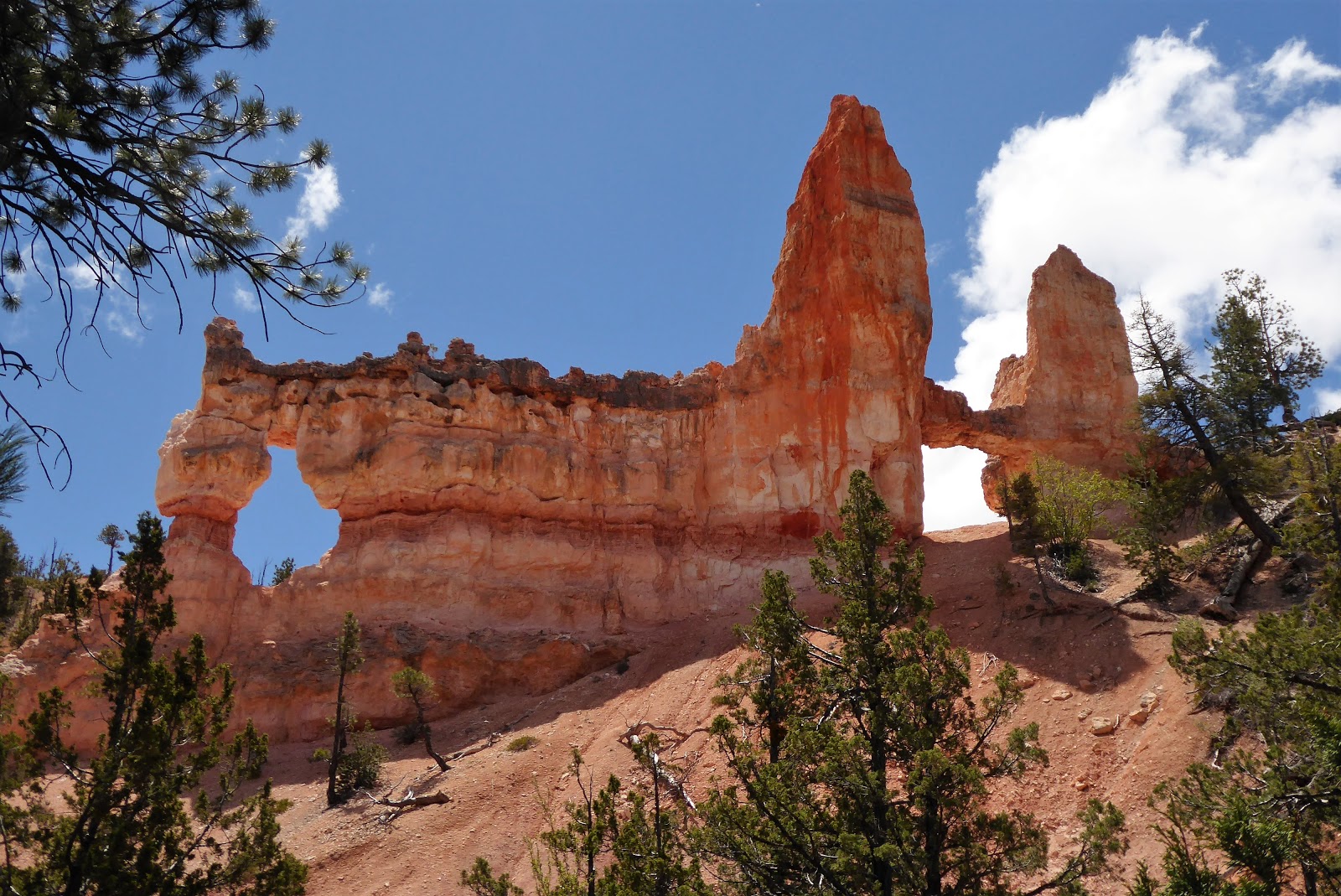
So what exactly is a hoodoo and why is
this area hoodoo heaven? The definition of hoodoo (noun) is “a pinnacle or
odd-shaped rock left standing by the forces of erosion.” Water is the hoodoo sculptor. Torrential rains
and melting snow erode the softer layers of rock, but the real force is “ice
wedging.” Bryce has over 200 days a year when the daytime temp is above
freezing, but then drops below freezing at night. (Yep, we can attest to that!) During
these freeze/thaw cycles water seeps into cracks in the rock, expands as it
freezes, and breaks the rock apart. Mother Nature never rests and the landscape
is continually evolving. (I realize it’s been awhile, but no, I don’t think the
hoodoos were that much taller last
time I was here. Lol.)
 |
| Thor's Hammer on the left. |
 |
| See, they haven't completely eroded since our last visit. :) |
 |
| Aquarius Plateau in the background. Sinking Ship Mesa is middle left. |
One of the challenges of hiking the
hoodoos is that all the major trails involve a significant amount of
uppy-downy. Elevation changes ranges from a paltry (cough) 600 feet on the
Queens Garden/Navajo loop, to 1571 feet on the Peekaboo Loop, to a toe
torturing/butt busting 1716 feet on the Fairyland Loop. And yep, we did all
three.
 |
| Switchbacks to get down to (and up from) the canyon floor. |
 |
| The trail also cuts through some of the sandstone fins. |
On Tuesday, we did the Peekaboo Loop. One
of the aspects of Bryce that I find fascinating is the variety of colors. The
hoodoos range from bone white to frosted pink, yellow, orange, pale lavender,
brick red and every combination and variation you can think of. Most of the
hoodoos are limestone, which in its pure state is basically white. Iron and
manganese in the stone have oxidized to produce an endless palette of colors.
 |
| The colors are unbelievable! |
 |
| The complexity and intricacy of the landscape is surreal. |
 |
| You can't not smile here! |
 |
| Hoodoos framed. |
 |
| The Window Wall. |
 |
| The pine trees provide some shade and welcome green. |
After the hike, we drove into town to
grocery up. We had a few smatterings of snow during the day but nothing that
lasted more than a few minutes. The forecast was for accumulations of 1-2
inches on Wednesday and we decided to make that a coach day. I decided to make
it a jammie day and stayed in them all day long. Lol. A couple of times it
snowed pretty hard but then it would warm up, so we never got enough to really
stick. With temps in the 20’s every night, dang it, I want more SNOW! Lol.
Thursday, we were back on the trails
for the Fairyland Loop. I was really hoping to get some pictures of snow on the
hoodoos, but there was only a light dusting left and that was mostly gone by
early afternoon.
 |
| Just a little snow left. :( |
 |
| View through a "window." |
 |
| Fairy Castle is the dark formation in the center. |
 |
| Mountain Columbine. Little joys along the trail. |
 |
| Rog on the trail. |
 |
| Boat Mesa. |
 |
| Lots of trees among the hoodoos in the valleys. |
 |
| Tower Bridge. Named after London Tower. |
 |
| More snow in the distance. |
We hadn’t done the 38-mile scenic
drive through the park yet, so we did that on Friday. Many of the overlooks are
just spectacular, but my very favorite is Inspiration Point. This is what I remembered from our trip in
1989! Well that and the cold, it was freezing
then too! Lol. Rog and I spent some time just watching the light change and the
clouds move across the landscape. It can make the same view look totally
different in a matter of minutes. We’ve seen some absolutely fantastic places,
but it would be hard to top Bryce for its sheer beauty and complexity.
 |
| Inspiration Point. You could spend hours here and not be bored. |
 |
| Incredible views in every direction. |
 |
Natural Bridge.
Since it was not formed by running water, strictly speaking, it is an arch, not a bridge. Lol. |
 |
| Aqua Canyon. |
 |
| Horseback riders in the canyon. Wouldn't that be fun? Next time!! |
 |
| Happy Hoodooers. :) |
Saturday was our last day here and the
warmest – mid 50’s. Woohoo! So we bundled up and went for a bike ride. There is
a very nice paved bike trail that runs from Bryce all the way to Red Canyon
State Park, about 15 miles away. Rog was itching to ride the mountain bike
trail in Red Canyon. It worked out great, because we could take the paved trail
to the mountain bike trailhead. Rog rode the Thunder Mountain trail all way to
the state park and the paved trail back to Bryce, 38 miles altogether. I was
content to ride just part of the way on the paved trail, about 15 miles, and
call it good. Rog did see some great scenery in Red Canyon and it looks like
another area that would be fun to explore. But, after hearing his stories and
seeing his newest rock rash, I’ll be doing it on foot! 😊
 |
| Rog got to bike among the hoodoos too! |
 |
| Thunder Mountain bike trail. |
 |
| Rog - mountain bike pano master! :) |
 |
| I snapped a shot of this local vacation home and RV parked next to the bike trail. Lol. |
We leave Sunday for Zion National
Park. We’re going to have to make some adjustments to our “jello plan.” I totally spaced on the holiday and had us
moving twice over Memorial Day weekend. Not smart. So we’ll probably hang out
around Zion a few days longer than we originally planned. We’re hoping for a
spot in the park, but if that doesn’t work out, Rog has several boondocking
options in mind. And you know how I hate to boondock. Lol!