As
some of you know, we have big plans for 2020 – we’ve booked a 15-day float trip
through the Grand Canyon! The Colorado River flows from Glen Canyon into the
Grand Canyon at Lee’s Ferry. We’re already excited about going and when we saw
an opportunity to do the section of Glen Canyon from the dam to Lee’s Ferry we
couldn’t resist. The Grand Canyon trip puts in at Lee’s Ferry, right where this
trip pulls out, so we won’t miss an inch! Lol.
We
booked our Glen Canyon float trip with Wilderness River Adventures. In 1963, with the construction of the Glen
Canyon Dam, Lake Powell was created and almost all of Glen Canyon was flooded
with water hundreds of feet deep. This float trip covers the 15 remaining miles
of canyon that isn’t under 400 feet of water.
The
trip started off with a bus ride from town, then through two miles of tunnel to
bring us down to the river below the dam. The tunnels were built as part of the
dam construction and it was interesting to see Glen Canyon Dam from the bottom
up.
 |
| A different perspective and yes, it looks really big from down here. |
Our boats
were motorized rafts that held about 20 people. We somehow ended up on the
kiddie boat (about half of our contingent was under 12), but the kids were nowhere
near as annoying as the gal sitting directly across from me taking endless
selfies. Sigh. Can you imagine what her photo album looks like? Page after page
of gorgeous scenery out of focus behind her smiling face. Lol.
 |
| No selfies here, just gorgeous scenery. |
 |
| Canyon walls reflected on the water. |
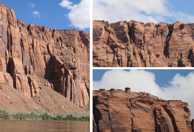
The
canyon is impressive, with towering red rock walls. We found out the same
outfitters that took us downriver will take folks upriver with their equipment and
drop them off below the dam. It’s an easy two-day flat water float. We just need to bring our kayaks and teach
Riley not to rock the boat! Something else to add to the list for next time.
 |
| Sheer cliffs tower above the river. |
 |
| There are several picnic areas and campsites along the river. |
 |
| It's a smooth flat-water float, can't wait to bring our kayaks! |
We stopped
for a break at one of campsites where we got to see petroglyphs made by ancestral
Puebloan Indians, the Anasazi. Another fun element of the trip was floating
around Horseshoe Bend and looking up at all the tourists looking down at us.
 |
Horseshoe Bend from above and below.
Now we're the little white boats along the shore. |
 |
| Do you see the tiny tourists on top? |
 |
| Anasazi petroglyphs. |
As
we approached Lee’s Ferry the terrain changed, instead of towering cliff faces
there were grasslands and different types of rock formations.
 |
| Different colors and formations as we exited Glen Canyon. |
 |
| A horse grazes on the open grasslands. |
 |
| Approaching Lee's Ferry. |
After
we left the boats, the bus took us back to Page. Unfortunately, with the
afternoon haze I couldn’t get a good picture of the Vermilion Cliffs. But we liked
the Lee’s Ferry area so much we made plans to come back.
 |
| Off the boat and onto the bus. |
 |
| The Vermilion Cliffs in silhouette. |
Our
last day at Lake Powell was a trip to Rainbow Bridge National Monument. Today,
the only way to reach Rainbow Bridge is by boat. Getting there is more than half
the fun!
 |
| Rog boards our boat, upper deck all the way for us! |
 |
| This beats paddling, at least when you're going 50 miles up and back! |
Glen
Canyon Dam impounds the Colorado River water to form Lake Powell. It took 17
years to completely fill the 186-mile-long lake. Although still controversial, no
one can deny that Lake Powell is beautiful. Filling the convoluted Glen Canyon,
the lake has 1960 miles of twisting shoreline. The water is a beautiful blue,
framing the intricate rock formations.
 |
| Gunsight Butte |
 |
| Rock formations form islands in the lake. |
 |
| Minerals in the water leave a "bathtub ring" along the shoreline. |
 |
| You have to wonder what the canyon looked like before it was flooded. |
 |
| The walls of Glen Canyon extend above Lake Powell. |
We
passed several marinas and got a fun peek at how the one percenters live. Some
of the house boats were huge – over 6000 sq feet of living space with a floor
below the water line! Can’t imagine what those would go for. We had fun reading
all the clever boat names, “Bucket List” was a favorite. There were lots of rentals available too, that
might be fun to do and more in my price range. Lol.
 |
| Somebody crossed this one off their list. Lol. |
Rainbow
Bridge is located in a narrow side canyon. We were impressed by the captain’s
skill as she maneuvered the boat through the tight, twisting turns. The lake
level fluctuates, near capacity, the water goes right up to the base of Rainbow
Bridge. Since levels were extremely low this spring, only 39% of full pool, we
had over a mile hike to the Bridge.
 |
| Leaving the main channel. |
 |
| Are you sure we'll fit?? |
 |
| Tight, twisty turns and we made it. |
 |
| The location of the dock changes with the lake level. |
 |
| On the hike, you can see where the water would be when the lake is higher. |
The
Rainbow Bridge is a spectacular stone arch that stands 290 feet high, spans 275
feet, and is 42 feet thick and 33 feet wide at the top. Long known to the
native tribes, it was first “discovered” in 1909 by a group of explorers led by
Paiute guides. Less than a year later, it was designated a national monument.
 |
| First glimpse of the bridge with Navajo Mountain in the background. |
 |
| The spectacular Rainbow Bridge. |
 |
| Greetings from Rainbow Bridge! |
We’re
sad to leave our beachfront spot on Lake Powell, but our next stop is the
campground at Lee’s Ferry. A gorgeous spot at the base of the Vermilion Cliffs
and Riley gets to play in the Colorado River.


I read a book in school on the making of Lake Powell and the dam. It was called All My Rivers Are Gone and speaks at length about the huge protests against the building of the damn, the historic artifacts that were flooded over, and destruction of native fish environment. I think you would enjoy it.
ReplyDeleteHey D. Thanks for the recommendation. So much of the history of water wars and development is really interesting. The Bureau of Water Reclamation and the Army Corps of Engineers have a lot to answer for.
ReplyDelete