We arrived at the Mono Lake Scenic
Area Visitor’s Center around noon on Friday, 6/9. (Happy Birthday,
Rian!!!) We talked to the staff about
camping options, then unhitched the mule and went exploring. Unfortunately, the
BLM boondocking spots we wanted were already occupied so we opted for the Lower
Lee Vining National Forest Campground. The campground is just a few miles out
of town on Hwy 120, situated under the pines on the banks of Lee Vining Creek. Not
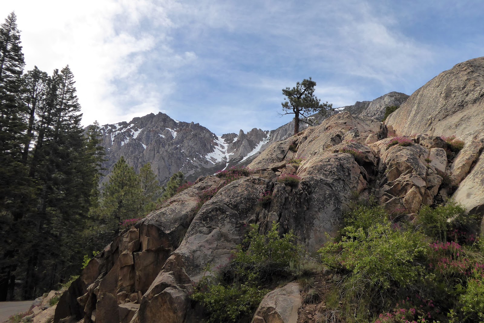
a bad Plan B. We also drove the scenic June Lake loop, where there are several
more campgrounds and fantastic views of the mountains.
 |
| Fantastic mountain views at the campground. |
 |
| The melting snow pack is creating some awesome waterfalls. |
 |
| Beautiful drive along the June Lake loop. |
 |
| Fields full of wild iris. |
Rog was familiar with this area from
his motorcycling days, but I’d never heard of Mono Lake and had no clue what
“tufa” was. Do you? Mona Lake is one of
the oldest lakes in North America, over 760,000 years old. It has no outlet, so
for thousands of years streams have carried minerals into the lake and, as the
water evaporated, the salinity increased. Mono Lake is twice as salty as the
ocean! No fish live in the alkaline waters, but it’s far from dead. Trillions
of tiny brine shrimp and alkali files are an all-you-can-eat buffet for
migratory birds.
So back to the tufa. Freshwater
springs containing calcium pump water into the carbonate-rich lake water.
Calcium carbonate forms, which is the limestone deposit that makes up the tufa.
Weird formations, spires and knobs of limestone, are formed under water and
then as the lake levels dip, they are exposed. They look a lot like cave
formations without the cave! Very cool.
 |
| Tufa formations at Mono Lake's South Beach. |
 |
| This formation is the nesting spot for a pair of ospreys. There are 30 breeding pairs at Mono Lake, since there are no fish in the lake, they chow down on the trout from the freshwater steams. |
 |
| Hard to imagine this was all under water when the tufa was formed. |
There is a second variety called “sand
tufa” that is formed when the spring water percolates through the sandy lake
bottom and incorporates the sand into the formation. Again, as the lake receded
the formations were exposed. It looks like rows and rows of intricate sand
castles make of solid rock. I’d never heard of tufa before, so it was fun to
learn about it and the history of the lake on a ranger-led tour.
 |
| Sand castles made of stone. |
 |
| A close up of the innards. :) |
 |
| I thought the sand tufa was super cool! |
 |
| These formations really look like they belong in a cave. Lol. |
Even though this ecosystem has
survived for millennia, it was nearly wiped out in the span of just one human
lifetime. Los Angeles acquired the water rights to the streams and diverted the
fresh water that fed into the lake. Evaporation didn’t slow down however, and as
the lake levels lowered, the salts levels rose so that everything would have
died. College students, conservationists, and others banded together and waged
a decades long court battle to get LA to allow some fresh water back into the
lake. They were successful, and while there is still a long way to go, the
situation is improving. This year’s record snow pack will certainly help.
In addition to the oldest lake in
North America, this area boasts the youngest mountains! The Mona craters are a
series of new(er) volcanic mountains, with Panum Crater only 650 years old. An
infant in mountain time. 😊 There is a hike around and then down
into the crater. There were huge boulders of obsidian, pumice, and other
volcanic rock. Fun fact – pumice is formed by an explosive eruption of frothy,
molten glass. It cools rapidly, trapping air inside. Obsidian is chemically
identical to pumice (I did not know that!), but it oozes out slowly and all the
air escapes before it hardens into glassy black rock.
 |
| The trail around Panum Crater. |
 |
| Huge boulders of obsidian. |
 |
| Volcanic rock plugs in the crater. |
The views were great hiking around the
crater. Then we followed a trail down into the crater which just sort of
disappeared into a huge rubble field. We ended up blazing our own trail over
the rocks. Lol.
 |
| Into the crater! |
 |
| Do you see the trail? Neither did we. Over the rocks it is. Lol. |
On Sunday, we braved the cold front
moving in to visit the historic mining ghost town of Bodie. In the late 1800’s
the town was a booming gold mining district with a population of 7-8,000, 30
different mines, and 9 processing mills. Mining continued until 1942. The last
major landowner hired caretakers to protect the remains of the town from
looters and vandals. Then in 1962 it became a state park. Over the years, a
series of fires destroyed most of the town and all but one of the mills, but
the remaining buildings are being preserved in a state of “arrested
decay.” Exteriors are repaired as
needed, but improvements aren’t made and the interiors are left as is.
 |
| The ghost town of Bodie. |
 |
| Lots of old mining equipment litter the town. |
 |
| All that was left of the bank after a fire was the brick vault. |
 |
| Rog outside the Firehouse, with this equipment no wonder most of the town burned down! |
 |
| The 1940's Shell Station. :) |
We were most intrigued by the amount
of personal property that was left in the buildings. A ranger explained that
the roads leading out of town were toll roads and the wagons leaving had to pay
by weight, so a lot of possessions were just abandoned. It was very
interesting, and would have been a lot more pleasant if the wind hadn’t kicked
up while the temperature dropped below freezing and it spit snow at us. I guess
that is somewhat fitting, as W.S. Bodey, after whom the town is named, died in
a blizzard just months after discovering gold here. Brrrrrrrr!
 |
| The assayers office. |
 |
| Ragged curtains still hang in the windows of this kitchen. |
 |
The old Schoolhouse. At one time there were over 600 children enrolled!
Although the ranger pointed out that most did not attend regularly. |
 |
| Interior of the old General Store. I'd like to go shopping! :) |
 |
| The telephone switchboard and an antique typewriter. |
Our plan to take Hwy 120 into Yosemite
had to be scrapped, the pass was closed and estimates were that it would remain
that way for a couple more weeks. The area had 200% of normal snow pack so many
roads and campgrounds are still closed. We hiked along Lee Vining Creek for a
few miles, it was beautiful but the stream was running very fast and high.
 |
| Lee Vining Creek. |
 |
| It was so cold the spray froze into icicles! |
 |
| We walked a couple miles past the spot where they had Hwy 20 closed. No snow down here. |
 |
| Pretty mountain meadows. |
 |
| We each claimed a tree! Lol. |
We leave Tuesday, 6/13, for
Markleeville, CA. There are a couple of BLM and National Forest campgrounds in
the area, so we’ll figure it out when we get there. See, I’m getting better at
this jello planning. 😊 Instead of reservations we have Plan
A, Plan B, and sometimes C and D. Lol.


I drove by Mono Lake and wondered about the odd formations. Thanks for filling in the research. :) It's too bad you didn't get to go over 120, that is such a beautiful drive. Next time I go to Yosemite I will likely camp along 120 and drive down into the valley. The crowds in the valley are crazy.
ReplyDeleteYeah, we were bummed about Hwy 120. It's hard to believe we went from "closed due to snow" to a week of over 100 temps. Every. Single. Day. We're melting...... The fridge has given it up, we've spent $40 on dry ice and need to get more today. We did manage to move to a space with hookups and that is helping. We have a few more days of this and then we'll move to St. Helena where it's in the balmy 80-90 range. Lol. Enjoy those 67 days. :)
Delete